
Infopoint with 3D Projection Mapping
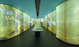
For the Ruhrverband, an interactive installation was developed to communicate the functionality of the fish lift at Baldeneysee—an advanced ecological infrastructure system designed to restore river continuity.
Concept
The project translates a highly technical hydraulic system into an intuitive, multi-layered visual experience. At its core is a CNC-milled 3D landscape model, serving as a physical interface for storytelling and exploration.
Installation & Interaction
- 3D-milled landscape model representing the Baldeneysee and surrounding topography
- 3D projection mapping using ceiling-mounted projectors, precisely aligned with the physical model
- Multiple interactive content layers, accessible via physical buttons
- Layered information system ranging from technical explanations to ecological context
Content Design
Each interaction reveals a different perspective:
- Hydrodynamics and flow guidance
- Fish behavior and migration pathways
- Mechanical lifting process inside the system
- Environmental and scientific background
Easter Egg (Hidden Layer)
A deliberately playful hidden feature was integrated:
- A secret “rainbow world” with unicorns, discoverable via interaction
- Designed to engage younger audiences and add an unexpected narrative layer
Technical Focus
The installation combines:
- Physical modeling (CNC milling)
- Real-time synchronized projection mapping
- Spatial calibration between digital content and physical geometry
- Interactive control logic for layered storytelling
Result
The project creates a precise yet accessible representation of complex infrastructure. It bridges engineering, environmental science, and immersive media—making the invisible processes of the fish lift both understandable and engaging for a broad audience.